
The wild dogs cry out in the night
Africa by Toto (music and lyrics by David Paich, Jeff Porcaro)
As they grow restless, longing for some solitary company
I know that I must do what’s right
As sure as Kilimanjaro rises like Olympus above the Serengeti
If Karaoke has taught us one thing it is that we can trust Toto to lay down a ripper of a chorus. But can we trust them with geography?
These are the hard-hitting questions I do not shy away from in this blog. Today we will investigate whether, in fact, Kilimanjaro can be seen from the Serengeti National Park, as asserted in Toto’s classic 80s song Africa.
Orientation
These fabled sites are both located in Tanzania, East Africa, separated by roughly 400 km of savanna and subtropical climes. Kilimanjaro stands almost 6km tall, its Kibo summit the highest point in the whole continent.
Is that high enough to be seen from such a considerable distance?

To answer this question we need three things. First: terrain data to map the area’s vistas. Secondly we need spherical trigonometry because the Earth is an oblong spheroid. And we need to consider the opacity of air: depending on atmospheric conditions, we can only see through so much air before it becomes too hazy. This is why rows of mountains appear more and more faint until they fade to white. Let’s ignore opacity for now and focus on lines of sight.
Data: Get NASA in the house!
A while ago NASA flew the SRTM satellite mission, which mapped the surface of earth for elevation at a resolution of 90 metres. I used these data to make the satellite view above (fetched here). There are some dead pixels here and there (areas of bad data coverage) but the cubes will do just fine for this project.
To test the data let’s create a cross-section of the mountains, standing at the bottom of the above image and looking north from a sea-level vantage point.
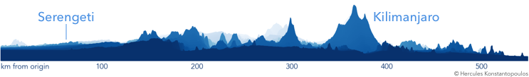
Each faded fold of land represents a certain distance, with lighter colours fading to white in the distance. Now, this is not a realistic view since there is no curvature correction in any direction. There is also some artistic license here: the y-axis is inflated by a factor of 10, in order to display a reasonable level of detail. To get more realistic we need some trigonometry.
Geometry: Make Euclid proud!
This is the slightly more complex part. A considerable distance separaes the two sites so we cannot approximate the terrain as flat. We need to sink background objects beneath the horizon, as dictated by curvature. The above image (artistic license remains in y-axis) is transformed to this:
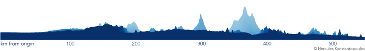
Some of the faraway mountains have disappeared below the horizon. So our depth perception, indicated by the colour fade, has become more detailed as the scale recalibrated.
The moment of truth
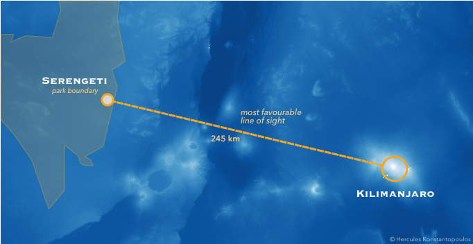
The centre of the Park is separated from the Kibo summit by 2.67 degrees of angular separation—that is, the angle dividing the radii connecting the centre of the earth to the two locations. The formulas are too boring to write down, but my calculation of the minimum height for a mountain to be seen at that distance is 6,906 metres.
Alas, the Kibo summit is 5,895 metres above sea level, a full kilometre too low to be seen from the heart of Serengeti Park.
But… full disclosure: I really want this to be true. So I’m going to try very hard to make it happen.
The shortest angular distance between the Kibo summit and lands plausibly within the Serengeti park is roughly 1.97 degrees. That sets the minimum elevation required in order to be seen to…
…4,845 metres above sea level 😮
We have 1,050 metres to spare! What if we map the elevation as seen from the boundary of the park?
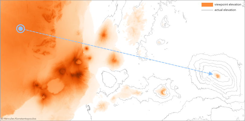
Here I have applied the effect of curvature away from our chosen viewpoint. Deeper colours are higher elevations, and white is below the horizon. The contours are the terrain map without perceived elevation applied, simply for geographical reference.
We can see Kibo in a glorious splash of colour, a lonely peak protruding above the horizon!
Can we call it?
Not yet. While the mountain is high enough to be seen through a clear line of sight, Serengeti is on a kilometre-high plateau, and other mountains separate the two sites.
Let’s plot the view from the edge of the Park toward the mountain. This time I will make the foreground translucent (α=0.05) and colour Kilimanjaro orange, to see if it manages to be seen between all those other mountains.
The moment of truth:

Folks… I am devastated. There is no orange here. Kibo is the little white-bordered blip in the background. I really thought we could pull this off together.
Kilimanjaro does not, in fact, rise like Olympus above the Serengeti.
How close did we get?
Even if the opacity of air would have got us at the end, I was hoping for a line of sight. Let’s have one final look at this curved earth landscape as a three-dimensional cube, viewed side-on.
Here I have coloured all terrain above the white horizon in purple and everything else in green.
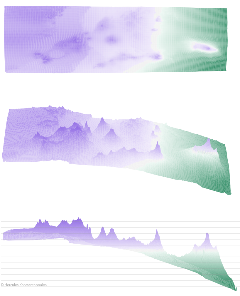
Close, but no smoking crater… Even though Kibo is nice and purple, the mountain range in the foreground is blocking our view.
What have we learned? First: trigonometry is fun. And second: if you want an over-developed and over-researched answer to a simple question, ask a scientist. When it comes to Karaoke-inspired frivolity we’ve got your back.

They didn’t say it could be seen from the Serengeti, merely that it’s “above” it, which is true.
LikeLike
That’s an interesting take @curmudgeon! I assume you don’t mean literally above so we have to interpret the poetry of ‘rising above,’ in reference to geographical features. I assume they mean ‘to be prominent with respect to,’ rather than just being higher. It isn’t particularly notable for the mountain to be taller than the adjacent flatlands!
But who knows… in the words of another rock star, Nick Cave, we call upon the author to explain!
LikeLike
OWW! Mien brain hertz
LikeLike